


HISTORY OF THE AREA
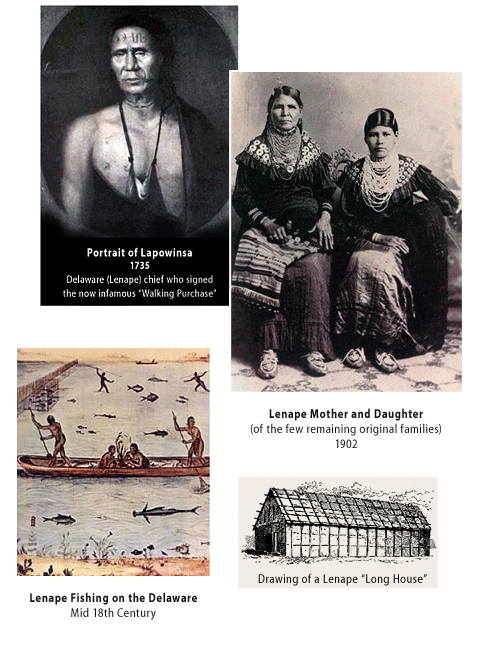
Before colonization in the late 1600s, the Lenape ("Original People") - also named by the arriving Europeans as the Delaware - inhabited the Philadelphia area. They lived in villages along streams, grew fruits and vegetables in fields and hunted in the mighty forest.
Our area and Cresheim Creek changed drastically when Germantown Township was founded in 1683. By the early 18th century the Lenape had been forced out, and by the late 19th century, only a few of that people existed on the East Coast.
In 1683 William Penn sold the land – which includes the six acres of new park land – to the first Quaker/Mennonite colonists of Germantown Township. By the early 1700s this land was part of a farm called Cresheim Farm. In the later 1800s the Gowen family bought most of upper East Mt. Airy and developed a suburban community which was made possible by the railroad connecting Chestnut Hill to downtown Philadelphia.
The forest was cut. Settlements, mills and farms were established. Soon Philadelphia became an industrial center. Along the Wissahickon, including Cresheim Creek, there were at one time over 60 watermills. In the 19th century the water was dangerously polluted through mills and sewage.
Reading Railroad President Franklin Gowen built a mansion with over 20 acres of lawn, including a lake along Cresheim Creek. The mansion and lake are long gone, replaced by housing, road and railroad development, except for these six acres, where remnants of the lake dam can still be seen.
The Fairmount Park Commission was founded in the later 19th century to preserve drinking water for the city. The Commission bought the old mill land and estates, including parts of the Wissahickon and Cresheim Creeks. Many people and organizations have worked ever since to preserve our beautiful valleys.
HISTORY OF THE LAND
Until 1683 the Unami Lenape inhabited the area and used the Cresheim Creek watershed for fishing and hunting, food planting and gathering. In mid-1600 Britain claimed the Atlantic East Coast as their colony. William Penn received Pennsylvania in 1682. In 1683 Penn granted Germantown Township (now Germantown, Mount Airy and Chestnut Hill) to fourteen German Quaker and Mennonite colonists. Immigration increased and small towns and farms were established. In 1703 Mennonites Margaret and Cornelius Tyson bought 50 acres (between what are now Germantown and Stenton Avenues, Roumfort Road and Mermaid Lane) and build Cresheim Farm. This piece of park is an undeveloped left-over piece of that farm.
SPECIAL FEATURES
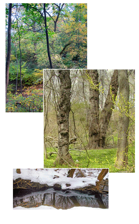
The park land and dissecting Cresheim Creek have been abused and neglected, but are an important oasis for wildlife and plants. A variety of mammals, including foxes live on the land. It provides habitat for local and migrating birds, which will increase as native plants and clean water become more available. The park features several old and rare trees, including: Tulip Poplar, Cork, Hickory, Black Locust, American Elm, Red Maple, Wild Cherry, Hornbeam, Beech and Polonia. The eastern side’s rock ledge (on Anderson Street) is the edge of the old Cresheim Farm Wissahickon Schist quarry. The southern side of the park is an artificial bank, erected to build the Crest Park Lane housing development. The southern boundary is the Chestnut Hill East train line, one of the oldest in the country. The northern park edge used to be the Fort Washington feeder branch of the Reading Railroad and is now owned by the Philadelphia Electric Company. During the later 1800s part of the land was an artificial lake. Remnants of the dam can still be seen.
THE WISSAHICKON EAST PROJECT
Cresheim Creek is 2.7 miles long. Half of it is now parkland. The rest runs through tunnels and alongside an old railroad bed, presently owned by PECO and a few businesses. The six acres (which include a small section of the Cresheim Creek) is parallel to the old Reading Railroad tracks east of Cresheim Valley Drive. This land is mostly accessible via entry at the intersection of Woodbrook Lane and Anderson Street in East Mount Airy. These acres are the only remaining land in East Mount Airy where the creek is still running free, through a woodland setting. The Wissahickon East Project’s goal was to incorporate the six acres into the Fairmount Park system, which has now been achieved, and help with its preservation, clean-up and renewal, which is now our primary mission.
For the last fifteen years neighbors have cleaned and protected the six acres. When they learned the land was owned by developers who were seeking to build a condominium complex of over twenty-five 1,200 sq. foot houses, neighbors started a campaign to save the land. The Wissahickon East Project was incorporated with this mission in 2004. After a long and arduous battle, the fight to stop the construction of the condominiums was won. With help from the Friends of the Wissahickon and the Chestnut Hill Historical Society, a conservation easement was negotiated that prohibits any future development on the land. Over the years it took to win the battle, the Wissahickon East Project has gained support from numerous local and neighborhood organizations, elected officials and businesses.
As of Spring 2010, Wissahickon East Project (WEP) is a non-profit-501(c)3 entity (tax-deductible) with a volunteer Board dedicated to rehabilitate the land and make it a neighborhood jewel instead of an eyesore.
In October 2013 the six acres were finally transferred from the developers to Philadelphia Parks and Recreation and are now part of Fairmount Park. This will allow us to help develop an environmentally-friendly community park.
© The Wissahickon East Project, 2010-2011.